Animation (.avi-file 55 MB).
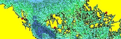
In the BEVIS-project a 3-D model is being developed to describe water flows in coastal areas. The water flows in the sea area around Åland during the first two weeks in July 2004 are presented in the animation below.
The red circles represent the locations of Öregrund, Mariehamn and Turku. The light green particles describe the flows of the surface water, and the dark green particles describe the flows deeper in the water column. The numerical drift model used in calculations is developed by Oleg Andrejev. The model grid is 463 m. The animation is done by Jacob Jones and checked by Anders Engqvist.
Animation (.avi-file 55 MB).
More animations (in Swedish): see Modellering.